There’s a tonne of signage around the Bay of Plenty, and lots with maps pointing people in all directions. But the maps Georgia Edwards creates are vital to the community.
Edwards works at Bay of Plenty Regional Council as a geospatial analyst. The job involves her collecting, managing and analysing map location-based data using Geographic Information Systems (GIS) to support decisions by the council. She also transforms spatial data from satellite imagery, LiDAR and field surveys into visual insights.
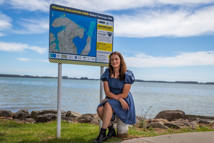
Her standout project for the council has been creating the region’s tsunami evacuation maps.
“I first got involved with the tsunami evacuation maps project in 2022 when the updating of maps from red/orange/yellow zones to one blue zone was being worked on,” Edwards said.
“They’re on public signs, so when my family visits, I can point and say, ‘I made that map’,” Edwards said. “It’s the most visible piece of work I’ve done and it helps keep people safe.”
She said it was a great opportunity to learn about communicating scientific data with the public. “It was interesting working with both the modelling outputs of where a tsunami was predicted to impact the region and then seeing this information turn into something easier to understand at a glance for the public.
“You really see how many ways the information can be interpreted and how important it is to consider every detail of the map.”
When Edwards tells people what she does for a living, the most common response is: “Haven’t all the maps been made?”
In light of this, she believes her role is often misunderstood. “People think I’m out exploring new lands,” she laughed.
“The reality is that geospatial mapping is about data and decisions – it’s critical to how we plan for the future.”
Edwards’ journey into this career began at Auckland’s Botany Downs Secondary College in geography class, thanks to an influential teacher, Miss Brodie.
“She was my geography teacher for Years 11- 13,” Edwards said. “She was passionate about GIS and made sure we did assignments that gave us hands-on experience.”
At the time, Edwards wasn’t convinced: “After a particularly frustrating day of software crashes, I told my friends I’d never, ever work in GIS. They love reminding me of that now.”
At university Edwards initially pursued microbiology alongside geography.
“I thought I’d work in a lab, but staring down a microscope all day wasn’t for me.”
A career workshop shifted her perspective, prompting her to think about what she wanted from her day-to-day life: variety, meaningful work and a role that made a difference. GIS ticked all the boxes.
At 19, Edwards secured a Prime Minister’s Scholarship for Asia and spent six weeks in Mumbai, interning with the Maharashtra State Government’s Mangrove Cell.
“I was very underqualified,” she said with a laugh. “They thought they were getting a PhD student!”
Tasked with analysing mangrove ecosystems, Edwards worked independently in a new culture, gaining invaluable experience that later helped her land her first job.
After graduating with a Bachelor of Science majoring in biological sciences and geography from the University of Auckland, Edwards joined Auckland Council’s bio information team, supporting projects that focused on biosecurity issues, such as kauri dieback and pest control.
“It was a lot of photos of deer poo and dead possums” – however, the role honed her technical skills and introduced her to the power of GIS in environmental management.
Three years ago she moved to Tauranga and a broader remit at the regional council.
“I wanted to branch out from biosecurity and work on a variety of projects,” she said. That variety had been everything she’d hoped for – including interactive dashboards for volunteer groups, mapping freshwater data and supporting teams across the organisation.
For Edwards, the visibility of this information matters because GIS often operates behind the scenes: “People don’t realise how critical it is to decision-making. Our maps and dashboards help teams track progress, secure funding and plan for the future.”
Edwards also serves on the New Zealand ESRI User Group Committee, helping organise regional conferences that connect GIS professionals across Waikato and Bay of Plenty.
“When I moved here, I didn’t know anyone in the local GIS scene. Now I help bring 100 people together every year. It’s about sharing knowledge and building community,” she said.
In future, Edwards wants to keep doing good work with good people.
“If my job contributes to something positive and I’m surrounded by supportive colleagues, that’s success for me.”
– Supplied Content